Reservoir Conditions
Access map products showing conditions for a subset of Reclamation reservoirs below.Interactive Reservoir Conditions Dashboard
An interactive dashboard showing current storage levels at 54 Reclamation reservoirs. Teacup diagrams illustrate current reservoir levels compared to average reservoir storage over a 30-year historical averaging period (10/1/1990 to 9/30/2020).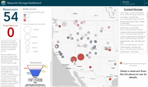
Static Reservoir Storage Map
A static PDF map showing storage conditions for seven major reservoirs and four major reservoir systems for any date between October 1, 1990 and yesterday. Beginning in 2000, reservoir conditions are overlaid on drought intensity data from the U.S. Drought Monitor.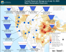
Select a date and click on 'Submit' to fetch the static map for a particular historical date
Date:
![]() DOCUMENTATION
DOCUMENTATION
Overview
The static reservoir storage map and interactive reservoir storage dashboard both show storage in acre-feet for a selection of operationally significant Reclamation reservoirs and reservoir systems. The static map includes data from 29 reservoirs, with eight individual reservoirs displayed on the map and an additional 21 reservoirs grouped into four reservoir systems displayed on the map, as shown in the table below. Storage data can be shown for yesterday's date and historical dates back to January 1, 1990. The interactive dashboard includes data from 54 individual reservoirs, as shown in the table below. Storage data for yesterday's date is shown in the map.
Data Sources
Reservoir storage data used in the maps is queried from Columbia-Pacific Northwest (CPN) Region Hydromet, Missouri Basin-Arkansas-Rio Grande-Texas-Gulf (MB-ART) Region Hydromet, Lower Colorado Basin (LCB) Region Hydrologic Database (HDB), Upper Colorado Basin (UCB) Region HDB, California Data Exchange Center (CDEC), and United States Geological Survey (USGS), as shown in the table below. Drought intensity data (displayed on the static map for dates after January 1, 2000) is retrieved as a feature service from Esri. Reservoir characteristics including site name, latitude, longitude, and maximum capacity for each reservoir included in the maps were obtained from Reclamation’s records.
Historical Statistics and Storage Comparisons
Historical statistics for reservoir storage were calculated for each day of the year over the period from October 1, 1990 through September 30, 2020. Historical statistics include: Maximum, 90th Percentile, 70th Percentile, 50th Percentile, 25th Percentile, 10th Percentile, Minimum, and Average. For individual reservoirs shown on the maps, the statistics were computed individually. For reservoir systems shown on the map, the daily storage was summed across all reservoirs in the system and statistics were computed on the combined time series.
The average storage statistic for each reservoir or reservoir system is shown in the teacup images on both the interactive dashboard and static map. The teacup images on the interactive dashboard also show the 10th and 90th percentiles. Maximum, 70th percentile, 50th percentile, 25th percentile, and minimum statistics are not shown on either map.
Comparisons of the reservoir storage for the specified date to the historical average, historical 50th percentile (median) and reservoir maximum capacity are calculated using the reservoir storage value on the specified date and the historical statistics and reservoir characteristics as described above. The following daily comparisons are calculated: Percent of Median, Percent of Average, and Percent Full (percent of maximum capacity).
Included Reservoirs and Data Sources | ||||
| * Not included in the interactive dashboard | ||||
| Reservoir | Region | PDF Map Representation | Data Source | RISE Catalog Link |
|---|---|---|---|---|
| American Falls | CPN | Part of Upper Snake System | CPN Hydromet | |
| Anderson Ranch | CPN | Part of Boise System | CPN Hydromet | |
| Arrowrock* | CPN | Part of Boise System | CPN Hydromet | |
| Bighorn/Yellowtail | MB-ART | Bighorn Lake | RISE | Location 275 |
| Blue Mesa | UC | RISE | Location 1533 | |
| Boysen | MB-ART | RISE | Location 281 | |
| Buffalo Bill | MB-ART | RISE | Location 269 | |
| Bumping* | CPN | Part of Yakima System | CPN Hydromet | |
| Calamus/Virginia Smith | MB-ART | RISE | Location 287 | |
| Canyon Ferry | MB-ART | RISE | Location 295 | |
| Carter | MB-ART | RISE | Location 288 | |
| Choke Canyon | MB-ART | RISE | Location 291 | |
| Clark Canyon | MB-ART | RISE | Location 294 | |
| Cle Elum | CPN | Part of Yakima System | CPN Hydromet | |
| Crane Prairie* | CPN | Part of Deschutes System | CPN Hydromet | |
| Crescent Lake* | CPN | Part of Deschutes System | CPN Hydromet | |
| Elephant Butte | UC | Elephant Butte Reservoir | RISE | Location 323 |
| Flaming Gorge | UC | RISE | Location 1535 | |
| Folsom | CGB | RISE | Location 334 | |
| Franklin Roosevelt – Grand Coulee | CPN | CPN Hydromet | ||
| Fresno | MB-ART | RISE | Location 337 | |
| Gibson | MB-ART | RISE | Location 342 | |
| Glendo | MB-ART | RISE | Location 345 | |
| Grassy Lake* | CPN | Part of Upper Snake System | CPN Hydromet | |
| Green Mountain | MB-ART | RISE | Location 353 | |
| Guernsey | MB-ART | RISE | Location 357 | |
| Haystack* | CPN | Part of Deschutes System | CPN Hydromet | |
| Horsetooth | MB-ART | RISE | Location 369 | |
| Hungry Horse | CPN | CPN Hydromet | ||
| Island Park* | CPN | Part of Upper Snake System | CPN Hydromet | |
| Jackson Lake | CPN | Part of Upper Snake System | CPN Hydromet | |
| Jamestown | MB-ART | RISE | Location 379 | |
| Kachess* | CPN | Part of Yakima System | CPN Hydromet | |
| Keechelus* | CPN | Part of Yakima System | CPN Hydromet | |
| Keith Sebelius/Norton | MB-ART | RISE | Location 390 | |
| Keyhole | MB-ART | RISE | Location 388 | |
| Kirwin | MB-ART | RISE | Location 391 | |
| Lake Cascade | CPN | CPN Hydromet | ||
| Lake Elwell/Tiber Dam | MB-ART | RISE | Location 396 | |
| Lake Granby | MB-ART | RISE | Location 351 | |
| Lake Havasu/Parker Dam | LCB | RISE | Location 3515 | |
| Lake Mead/Hoover Dam | LCB | Lake Mead | RISE | Location 3514 |
| Lake Mohave/Davis | LCB | RISE | Location 3513 | |
| Lake Owyhee | CPN | CPN Hydromet | ||
| Lake Powell | UC | Lake Powell | RISE | Location 393 |
| Lake Sherburne | MB-ART | RISE | Location 475 | |
| Lake Tschida/Heart Butte | MB-ART | RISE | Location 402 | |
| Lucky Peak (owned by United States Army Corps of Engineers) | CPN | Part of Boise System | CPN Hydromet | |
| McGee Creek | MB-ART | RISE | Location 408 | |
| McPhee | UC | RISE | Location 410 | |
| Millerton | CGB | RISE | Location 413 | |
| Minidoka* | CPN | Part of Upper Snake System | CPN Hydromet | |
| Navajo | UCB | RISE | Location 423 | |
| New Melones | CGB | New Melones | RISE | Location 3204 |
| Ochoco* | CPN | Part of Deschutes System | CPN Hydromet | |
| Palisades | CPN | Part of Upper Snake System | CPN Hydromet | |
| Pathfinder | MB-ART | RISE | Location 433 | |
| Pueblo | MB-ART | Pueblo Dam | RISE | Location 445 |
| Prineville* | CPN | Part of Deschutes System | CPN Hydromet | |
| Rimrock* | CPN | Part of Yakima System | CPN Hydromet | |
| Ririe* | CPN | Part of Upper Snake System | CPN Hydromet | |
| Seminoe | MB-ART | RISE | Location 467 | |
| Shadehill | MB-ART | RISE | Location 476 | |
| Shasta | CGB | Shasta Lake | RISE | Location 471 |
| Trinity | CGB | RISE | Location 3203 | |
| Upper Klamath Lake | CGB | Upper Klamath Lake | USGS | |
| Waconda/Glen Elder | MB-ART | RISE | Location 504 | |
| Whiskeytown | CGB | RISE | Location 509 | |
| Wikiup* | CPN | Part of Deschutes System | CPN Hydromet | |
Reservoirs included in PDF Map | |
| * Not included in the interactive dashboard | |
| Reservoir/Reservoir System | Included Reservoirs |
|---|---|
| Bighorn Lake | Bighorn Lake |
| Elephant Butte Reservoir | Elephant Butte |
| New Melones | New Melones |
| Lake Mead | Lake Mead |
| Lake Powell | Lake Powell |
| Pueblo | Pueblo |
| Shasta Lake | Shasta Lake |
| Upper Klamath Lake | Upper Klamath Lake |
| Deschutes System | Wickiup* |
| Crane Prairie* | |
| Crescent Lake* | |
| Prineville* | |
| Ochoco* | |
| Haystack* | |
| Upper Snake System | American Falls |
| Jackson Lake | |
| Palisades | |
| Ririe* | |
| Grassy Lake* | |
| Island Park* | |
| Minidoka* | |
| Boise System | Anderson Ranch |
| Lucky Peak (owned by United States Army Corps of Engineers) | |
| Arrowrock* | |
| Yakima System | Cle Elum |
| Kachess* | |
| Keechelus* | |
| Bumping* | |
| Rimrock* | |
To retrieve the data for the reservoirs in the visualizations that are available in RISE, use the RISE API results endpoint. The RISE API results endpoint root URL is: https://data.usbr.gov/rise/api/result
Query parameters are available to filter results by location ID, parameter ID, date.
Example of the URL structure with template parameters:
https://data.usbr.gov/rise/api/result?locationId=<LOCATION_ID>¶meterId=<PARAMETER_ID>&dateTime[before]=<START_DATE>&dateTime[after]=<END_DATE>&catalogItem.isModeled=false
Full query example URL:
https://data.usbr.gov/rise/api/result?locationId=1533¶meterId=3&dateTime[before]=2024-05-01&dateTime[after]=2024-01-01&catalogItem.isModeled=false
Collapse documentation display...
